
The international project, PanAfGeo2, is targeted at the practical improvement and capacity building for the staff of geological surveys of African states.
It has been moving around Africa, to anchor the crucial practical training in the field of geoscientific mapping in Windhoek. It is supported by the EU and co-financed by 12 European geological surveys united under EuroGeoSurveys.
Its “Work Package A” is focused on practical skills in the field of geoscientific mapping and represents the most variegated work package of seven work packages included in the programme. The WP A training in Namibia opens the second phase of the programme, in Windhoek after three years of rotation through Ethiopia, Morocco, Senegal and Namibia.
The awarding of the participants’ certificates and the official closing ceremony will be held at the Geological Survey of Namibia on Friday 28 September, at 14h00. The first training of the second phase of the “Field Geoscientific Mapping” programme followed the courses held during the first phase in Ethiopia, Namibia, Morocco and Senegal.
It focuses on the intense practical teaching of the petrological, structural, geophysical, and geochemical methods required for the construction of geological maps on different scales, of which the 1:25 000 was applied in the training. An important role in the mapping process is played by remote sensing and GIS approaches that are forming a major part of the theoretical training segments.
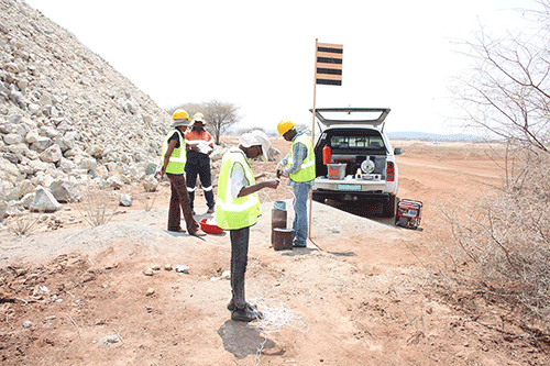
The programme takes 28 days, combined with hands-on lectures, field excursions, demonstrations, practice in instrumental methods, and a mapping part. The field part was conducted in small groups of trainees, each of them supervised by one expert. The training was coordinated by the Czech team and launched thanks to the joint effort of the experts from the Czech Geological Survey (CGS), Portugal Geological Survey (LNEG) and the Geological Survey of Namibia (GSN), supported also by local independent
experts.
A total number of 25 trainees representing 13 African countries are being trained during this course, accompanied also by junior staff members of the GSN. The introductory and field data processing sessions took place at the Geological Survey of Namibia in Windhoek. The field part was held in the geologically varied areas in the Etusis and Abbabis formations of the Damara Belt.
The area south of Karibib represents ideally exposed and geologically variegated terrain, famous for numerous mineralogical occurrences and rich mining history. The methodical and mapping processes included excursions to several active mining sites in the Karibib area.
The PanAfGeo2 WPA-N1 training in Namibia opens the whole programme of the second phase of the Work Package A activities focused on the field of geoscientific mapping. A final in-door session is scheduled to take place between 19 and 28 September in the GSN, Windhoek.
The final ceremony is anticipated to be held in the auditorium hall in the GSN, Ministry of Mines and Energy, on 28 September.